
About the UK Soil Observatory map viewer
The UK Soil Observatory (UKSO) map viewer helps you explore the soil environment around where you live and puts soil maps at your fingertips. View soil property information from a range of data providers and contribute information about your soil.
System Requirements
The UK Soil Observatory (UKSO) map viewer is built on top of the ESRI JS API v4. Here are a couple of links to the minimum requirements to use this API:
Navigation
Choose where you would like to investigate. Enter a placename or postcode of interest in the search box indicated in the image below.
Alternatively, use the icon in the bottom-right of the map to centralise the map view at your current location (as calculated by your mobile device or computer).
![]()
Move around the map by left-clicking and dragging the mouse in the direction you wish to travel. To zoom in or out of the map, use the plus and minus buttons on the bottom- left of the map. Alternatively, you can use the mouse wheel to zoom in and out of the map. Holding the Shift key and dragging a rectangle allows you to zoom in to that extent.
![]()
Map navigation guide
Add map layers
Click the layers button (below the map) to add data to the map.

Initially, all available map layers are listed, grouped by Topic. By clicking on the 'Organisation' button map layers will be grouped by Organisation. Click on the Topic/Organisation name to see the layers listed under that Topic/Organisation. By selecting the ‘Search’ option, a search term can be entered to return a list of matching layers.
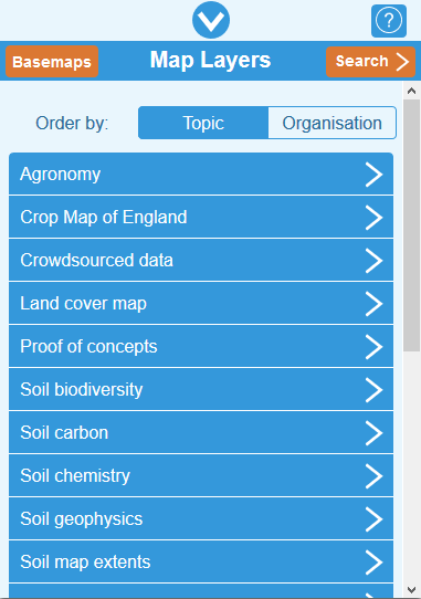
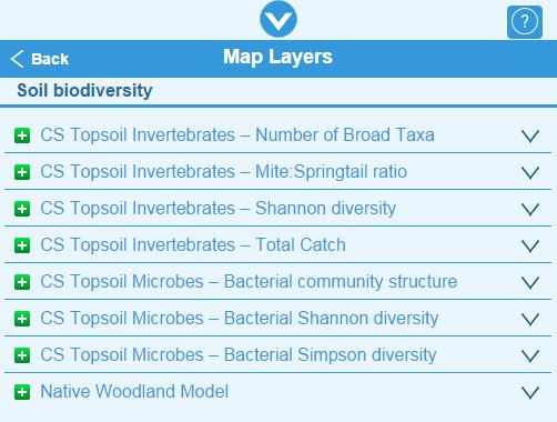
When presented with a layer list for a Topic/Organisation, click '˅' associated with a layer to view a summary of the layer. Click the green plus button to add the layer to the map. In mobile mode only one layer can be added to the map at a time.
Once added to the map, the layer details appears below the map. Added map layers are automatically displayed on the map. A layer’s visibility can be switched off by unticking the checkbox to the left of the layer name.

Other functionality available for each layer:
![]() - provides further
information about the layer with a link to more detailed information
- provides further
information about the layer with a link to more detailed information
![]() - provides a
legend image for the data layer
- provides a
legend image for the data layer
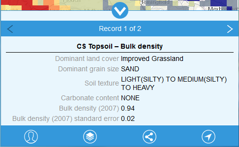
Querying map features
Click on a feature displayed on the map to find out about its attributes. All features from the currently displayed map layer will be returned. Use the '<' and '>' arrows to step through the attributes of all features returned.
Crowdsourcing
Tell us about your soil. Join our crowdsourcing initiative by submitting your own soil data or validating CEH Land Cover Map to help us improve our knowledge about the properties of soils.
Click the icon in the bottom-left of the map (see below) to open the crowdsourcing menu, where you can:
![]()
Crowdsourcing: Show Records
Click on Show Land Cover Records or Show Soil Records to open a list of the Crowdsourced layers. Click on a layer to add it to the map.
Records submitted by UKSO users and mySoil app users are displayed. Click on a point to see the information and any photographs provided. Click on the photo to open it in a new tab.
Crowdsourcing: Add Soil Record
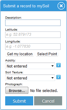
Having seen the information others have contributed, click Add Soil Record to tell us about your soil.
Complete the displayed form to describe your soil, provide a location (by clicking on the map or using your current location as calculated by your computer or mobile device), indicate acidity and soil texture and include a photograph. Click on the 'i' buttons to get help on selecting an acidity or soil texture values. Click Submit and your record will be validated and made available via the UKSO as soon as possible.
Crowdsourcing: Add Land Cover Record
Help to validate the accuracy of the CEH Land Cover Map 2015 by using either your local knowledge or the aerial photography provided as a basemap. The collected data will be stored and used to improve the accuracy of the dataset.
To get started go to Contribute/Add Land Cover Record. The Land Cover Map Layer will be automatically added and the basemap will change to aerial photography. Now zoom in on an area that you wish to validate. If you toggle the layer on and off you'll be able to better compare the Land Cover Map to the background. Tapping anywhere on the map will give you the land cover information at that location as well as the option to validate it.
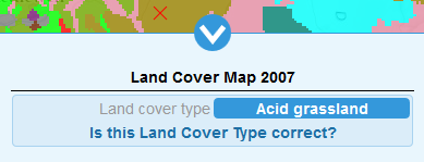
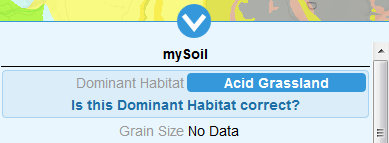
Note that the same option is given after querying the layer mySoil. Even though the attribute is called "Dominant Habitat", the information cames from the same database as the land cover.
If you click on the option to report whether the value is correct, a submission form will pop up. This form shows the current land cover type for the given location allowing you to submit whether the value is correct as well as (optionally) uploading a photo. If you decide that the value is incorrect you must suggest a more appropriate value from a drop down list before submitting.
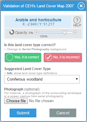
The form above also presents a link to select the aerial photography backgrond and a link with the definitions of the different land cover types.
Share
Click the button below to share the layer you are currently viewing at your location through Twitter, Facebook or by email.

View desktop version
The UKSO is available in two modes – mobile and desktop - UKSO detects whether you are using a desktop computer or mobile device and provides the most appropriate version. You can manually switch between desktop and mobile versions. When in mobile mode, click the switch icon to view the UKSO in desktop mode.
![]()
Note if UKSO detects you are using a mobile device you will be unable to switch to the desktop version.
Privacy Settings
This website uses Google Analytics to help analyse how visitors use this site in order to improve the user experience. Google Analytics uses “cookies”, which are small text files placed on your computer, to collect standard internet log information and visitor behaviour information in an anonymous form. More Information.
To enable/disable use of Google Analytics use the button below:
Terms of use and copyright
The UKSO website is hosted by the British Geological Survey and as such is subject to their terms of use for websites.
Presented data layers are provided by the UKSO partners and the Ordnance Survey. IPR and copyright details for each layer are indicated in its layer information.
Additionally, the UKSO map viewer contains Ordnance Survey data Crown Copyright and database right 2016. Other basemap sources include Esri, DigitalGlobe, geoEye, i-cubed, USDA, AEX, Getmapping, IGN, IGP, swisstopo and the GIS User Community.
Crowdsourced information
By uploading and depositing photos or materials, you, as depositor, do so on the understanding they may be used/re-used by others.
By depositing photos and materials you take full responsibility:
1. to ensure that they are owned by you (or you have permission to do so); and
2.understand that liability regarding their use/re-use may lie with you as depositor.
If there are doubts about ownership, check first before making a deposit on UKSO.
This data is licensed under the Open Government Licence. Records submitted prior to 30 June 2016 are licensed under a Creative Commons Attribution-NonCommercial 3.0 Unported License
![]()
Further Help
For further help Email enquiries@bgs.ac.uk.